


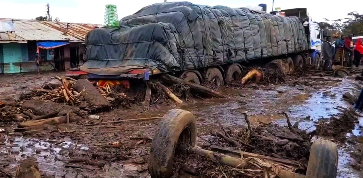
The number of people who lost their lives during the massive debris avalanche from Mount Hanang, is currently rushing towards 90.
But what really happened in Katesh? Did the volcano on the nearby Mount Hanang really erupt as many villagers have been suspecting?
On early Sunday Morning of December 3, 2023, a colossal landslide discharged from Mount Hanang swept down onto Katesh Township and surrounding villages burying buildings and farms as well as destroying infrastructure.
Prime Minister Kassim Majaliwa reports that the number of deceased has so far reached 87 and counting.
Some people in the area claimed that the mudflow emanating from Mount Hanang was steaming hot, indicating the possibility of some seismic forces behind the deadly debris avalanche.
We therefore contacted Dr. Ben Beeckmans, an expert Volcanologist, Environmental Scientist and Physical Geographer and a member of the International Association of Volcanology and Chemistry of the Earth’s Interior (IAVCEI), to explain the situation.
“As you know I do not live in Tanzania, and no, I have not yet heard of the landslide,” wrote Dr Beeckman, a Belgian who in the past used to live in Arusha, running the scientific research institution known as Ecoscience Limited as Director.
Previously, the scientist was researching volcanoes in the Democratic Republic of Congo, to an extent of being labelled ‘The Man who plays with fire!’
All the same, according to the Volcanologist, most of the volcanoes in Northern Tanzania had partial collapses in their history because they happen to be situated in a tectonically active area, the East African Rift Valley.
Dr Beeckman points out that about 9000 years ago, Tanzania’s second highest peak, Mount Meru, had one of the most important debris avalanches (landslides), like the one which recently occurred in Hanang.
Evidence of the Meru avalanche, as far as Dr Beeckman is concerned, remains extremely visible today on its Eastern side of the mountain.
As for the Mount Hanang Avalanche, the scientists said: “It is probably way too soon to speak about an eruption, even though the word “hot mud” as described by some villagers, might indicate there is some activity underneath.
“Unfortunately, Tanzania has no active network of seismic monitoring or other, and without that, any provision becomes impossible,” said the Volcanologist.
“I remind you that years ago, I gave many lectures to local organizations in Tanzania, but nobody seemed to be interested. So, what can one do? Only suffer the consequences when they arrive,” warned Dr Beeckman.
“For the moment, I cannot say more. I will come to Tanzania next March or April and maybe if someone can get people from the area together, I can teach them about volcanic hazards and what to do. But logistics must be for them,” the scientist concluded.
During his time in Tanzania, Dr Ben Beeckmans, the expert volcanologist, gave a series of conferences about volcanic risks and advised that a seismic net on both Mount Meru and Kilimanjaro was a necessity for monitoring these huge volcanoes.
He also authored “an introduction to the tectonics and the volcanics of Northern Tanzania!”
With its peak summiting at 3,420 meters above sea level, Mount Hanang located in Hanang District, is the country’s fourth highest peak after Mount Kilimanjaro, Mount Meru and Mount Loolmalasin.
Mount Hanang protrudes above Lake Balangida in Manyara Region, Northern Tanzania.
Comments are closed, but trackbacks and pingbacks are open.